Geodata International
This programme is presented to you by:
Postfach 400225
47896 Kempen
Deutschland / Germany
| E-mail: | info [at] killetsoft [dot] de |
| Phone: | ++49 (0)2152 961127 |
| Facsimile: | ++49 (0)2152 961128 |
| Website: | www.killetsoft.de |
| Category: | Business / Databases & Tools |
| Version: | 9.03 |
| Release date: | 2017-08-24 |
| Size: | 1.97 MB |
| OS: | Win 98 / ME / 2000 / XP / Vista |
| Requirements: | All systems |
| Languages: | German, English |
| Downloads: | 2 in April / 398 in total |
Rating: 1.00/10 (7 votes cast)
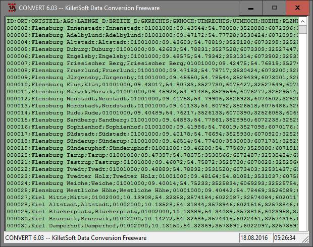
Geodata International - World-wide database of countries with georeferenced towns, municipalities, postal codes and administrative units with WGS84 and UTM coordinates and elevations for geocoding, proximity search, navigation, distance calculation. Often is it necessarily, for an address characteristic, e.g. the place name or the postal code, to establish a local relationship - a georeference. The georeference can be used e.g. to show a customer the nearest chain store by doing a proximity search. On the basis of the georeferences business zones, statistics or general maps can be made. Towns, municipalities and postal codes can be assigned to the superordinated administrative units. Distances between places or postal areas can be determined with the coordinates contained in the database tables. For that the georeferences are available in all country database tables as UTM coordinates on the natural and an uniformly meridian strip and as geographical coordinates in degree and deg/min/sec notation. With the elevation data from a Digital Elevation Model the ground level height of each place can be determined. The database tables are present in the file format CSV (Comma Separated Values). The character set used is UTF8. This format is used often and in most cases you can import data directly into your own data system. The freeware program CONVERT, downloadable from the KilletSoft site, converts the available database tables to other data formats and character sets with the necessary sortings and selections. With the program, for example, CSV data can be converted to the SDF format (Simple Document Format) or to the dBase format. For the use of the data on different platforms it is possible to select between the character sets ASCII, ANSI, UTF8 and UniCode. Thus the import of the data in any database management system or file system will be possible.
Here you can subscribe for the update infos for this programme. You will then receive an e-mail notice each time an update has been submitted for this programme.
In order to subscribe for the update infos, please enter your e-mail address below. You will then receive an e-mail with a link, which you need to click in order to confirm you subscription.
You can unsubscribe from the list at any time. For this purpose, you will find a link at the end of each update info e-mail.
This service is completely free of charge for you.