TOPOWIN
This programme is presented to you by:
Postfach 400225
47896 Kempen
Deutschland / Germany
| E-mail: | info [at] killetsoft [dot] de |
| Phone: | ++49 (0)2152 961127 |
| Facsimile: | ++49 (0)2152 961128 |
| Website: | www.killetsoft.de |
| Category: | Business / Databases & Tools |
| Version: | 23.02 |
| Release date: | 2024-03-06 |
| Size: | 4.54 MB |
| OS: | Win 2000 / XP / 2003 / Vista / 7 / 8 / 10 |
| Requirements: | Pentium, 50 MB HD |
| Languages: | German |
| Downloads: | 3 in May / 815 in total |
Rating: 4.00/10 (7 votes cast)
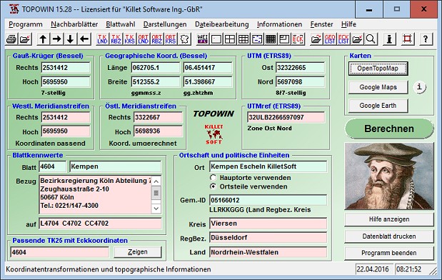
TOPOWIN is a state-wide register of the German Topographic Cartographies, the German Basic Cartography and of localities with geo references in different coordinate systems. It is also a topographic information system. In the division of planning and execution of economical and scientific projects frequently topographic documents are used. The program TOPOWIN makes information available of the official topographic cartographies and the German Basic Cartography from the entire national territory in suitable graphic views. It accomplishes different coordinate transformations and inquiries. The program was developed under co-operation of the land surveying authorities of many German Federal States. For the first time in the previous version TOPO (for DOS) and later in TOPOWIN state-wide topographic information were arranged for the data technical evaluation. The program is for consulting engineers, planning authorities and users of topographic maps a useful and versatile tool. The topographical maps of different standards, required for a project, can be determined by the entering of known parameters or by the direct selection from overview graphics and from sorted lists. By the investigation of topographical records on the basis of known places, a data base with more then 105.000 places and residential districts is available. The program TOPOWIN calculates with Gauss Krueger coordinates and Geographic Coordinates refering to the Potsdam Datum (Bessel ellipsoid with central point Rauenberg). It also works with UTM coordinates and UTMRef coordinates in the NATO standard, which refer to the datum ETRS89 (GRS80 / WGS84, geocentric).
Here you can subscribe for the update infos for this programme. You will then receive an e-mail notice each time an update has been submitted for this programme.
In order to subscribe for the update infos, please enter your e-mail address below. You will then receive an e-mail with a link, which you need to click in order to confirm you subscription.
You can unsubscribe from the list at any time. For this purpose, you will find a link at the end of each update info e-mail.
This service is completely free of charge for you.