Total GIS Converter
This programme is presented to you by:
Rossoshanskaya 7-1a-62
117535 Moscow
Russian Federation
| common [at] winFrigate [dot] com | |
| Phone | +7-916-153-4006 |
| Facsimile | +7-916-153-4006 |
| Website | www.CoolUtils.com |
| Category: | Graphic Apps / CAD |
| Version: | 1.5 |
| Release date: | 2013-03-01 |
| Size: | 7.59 |
| OS: | Win 98 / ME / 2000 / XP / 2003 / Vista |
| Requirements: | A standart windows PC |
| Languages: | German, English |
| Downloads: | 10 in July / 94 in total |
Rating: 2.25/10 (4 votes cast)
| Download: | www.CoolUtils.com/download/TotalGISConverter.exe |
| Infopage: | www.CoolUtils.com/TotalGISConverter |
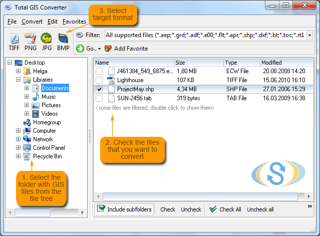
Total GIS Converter is an affordable converter of GIS files. It converts AEP, GRD, ADF, E00, FLT, APR, SHP, DXF, BT, TOC, RT1, DEM, DLG, ECW, IMG, DGF, GML, SID, MIF, TAB, WOR, DNG, DDF, BIL, TIF, JPEG, TTKPS, TTKGP, TTKLS, LFT, PFT, and TFT files. The target formats are TIFF, PNG, JPEG, BMP. The program can scale your GIS files to optimize their size. Besides, it can slice the output files to several parts. Total GIS Converter has easy-to-understand interface plus command line support. Try it for free. Download the trial version now and convert your GIS files.
Show / Hide
Here you can subscribe for the update infos for this programme. You will then receive an e-mail notice each time an update has been submitted for this programme.
In order to subscribe for the update infos, please enter your e-mail address below. You will then receive an e-mail with a link, which you need to click in order to confirm you subscription.
You can unsubscribe from the list at any time. For this purpose, you will find a link at the end of each update info e-mail.
This service is completely free of charge for you.